By Danwei Tran Luciani
Knowing the location of your users can help boost the quality of your Web site and the speed of your service. In the past, users had to actively input their location and submit it to a site, either by typing it, using a long drop-down list, or clicking a map. Now, with the HTML5 Geolocation API, finding your users (with their permission) is easier than ever. Figure 1 shows a Web site using geolocation to determine the location of a user, represented in latitude and longitude. The numbers can easily be translated into something more understandable, such as the street name or city.
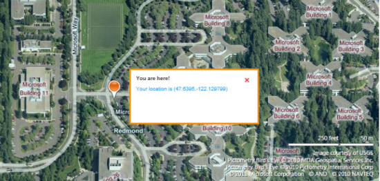
Figure 1 Showing a User’s Location with the Help of Geolocation
Imagine how useful your site could be if it provided online timetables for all public transportation in a particular city. Using geolocation, the site could recommend optimal travel routes to get people where they’re going as quickly as possible. Desktop users could get their start location sorted by proximity to their computer. Mobile users trying to get home after a night out could quickly find the closest bus stop within walking distance. These possibilities and more are just an API away.
Scenarios for Using the Geolocation API
Here are 12 simple scenarios that illustrate how a Web site can accommodate users and customize their experience by taking their location into account. Some of them might seem obvious, but the small things often make the biggest differences.
· Public transportation sites can list nearby bus stops and metro locations.
· Late night out? Taxi or car service Web sites can find where you are, even if you don’t know.
· Shopping sites can immediately provide estimates for shipping costs.
· Travel agencies can provide better vacation tips for current location and season.
· Content sites can more accurately determine the language and dialect of search queries.
· Real estate sites can present average house prices in a particular area, a handy tool when you’re driving around to check out a neighborhood or visit open houses.
· Movie theater sites can promote films playing nearby.
· Online games can blend reality into the game play by giving users missions to accomplish in the real world.
· News sites can include customized local headlines and weather on their front page.
· Online stores can inform whether products are in stock at local retailers.
· Sports and entertainment ticket sales sites can promote upcoming games and shows nearby.
· Job postings can automatically include potential commute times.
How Geolocation Works
Technically speaking, a PC or a mobile device has several ways to find out its own location (hopefully, in the same place as the user).
§ GPS is the most accurate way to determine positioning, but it’s less energy efficient than other options and sometimes requires a lengthy startup time.
§ A-GPS (assistive GPS) uses triangulation between mobile phone towers and public masts to determine location. Although not as precise as GPS, A-GPS is sufficient for many scenarios.
§ Mobile devices that support Wi-Fi access points can use hotspots to determine the user’s location.
§ Stationary computers without wireless devices can obtain rough location information using known IP address ranges.
When it comes to sharing the physical location of users, privacy is a serious concern. According to the Geolocation API, “user agents must not send location information to Web sites without the express permission of the user.” In other words, a user must always opt in to share location information with a Web site. Figure 2 shows a typical message requesting a user’s permission. For more information about ensuring security with the Geolocation API, see Security and privacy considerations.
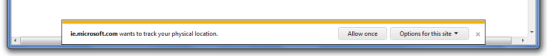
Figure 2 Sample User Permission Request
Three Simple Functions
Are you ready to incorporate geolocation into your Web site? You need to learn only three simple functions to master the entire API, which resides within the geolocation object, an attribute of the Navigator object. (Learn more about the geolocation object here.)
The getCurrentPosition function gets the user location one time. It takes two arguments in the form of callbacks: one for a successful location query and one for a failed location query. The success callback takes a Position object as an argument. It optionally takes a third argument in the form of a PositionOptions object.
1. navigator.geolocation.getCurrentPosition(locationSuccess, locationFail);
2.
3. function locationSuccess(position) {
4.
5. latitude = position.coords.latitude;
6.
7. longitude = position.coords.longitude;
8.
9. }
10.
11. function locationFail() {
12.
13. alert(‘Oops, could not find you.’);
14.
15. }
The Position object contains the properties shown in Figure 3.
Figure 3 Properties of the Position Object
|
Property
|
Value
|
Unit
|
|
coords.latitude
|
double
|
degrees
|
|
coords.longitude
|
double
|
degrees
|
|
coords.altitude
|
double or null
|
meters
|
|
coords.accuracy
|
double
|
meters
|
|
coords.altitudeAccuracy
|
double or null
|
meters
|
|
coords.heading
|
double or null
|
degrees clockwise
|
|
coords.speed
|
double or null
|
meters/second
|
|
timestamp
|
DOMTimeStamp
|
like the Date object
|
The watchPosition function keeps polling for user position and returns an associated ID. The device determines the rate of updates and pushes changes in location to the server.
The clearWatch function stops polling for user position. It takes the ID of watchPosition as an argument.
Presenting Location Data: Geodetic or Civic
There are two ways of presenting location data to the user: geodetic and civil. The geodetic way of describing position refers directly to latitude and longitude. The civic representation of location data is a more human readable and understandable format.
Each parameter has both a geodetic representation and a civic representation, as illustrated in Figure 4.
Figure 4 Examples of Geodetic and Civic Data
|
Attribute
|
Geodetic
|
Civic
|
|
Position
|
59.3, 18.6
|
Stockholm
|
|
Elevation
|
10 meters
|
4th floor
|
|
Heading
|
234 degrees
|
To the city center
|
|
Speed
|
5 km / h
|
Walking
|
|
Orientation
|
45 degrees
|
North-East
|
When using the Geolocation API, you get the geodetic data back from the functions. Presenting location data in raw numbers is rarely friendly or useful. Online services, such as Bing Maps and Yahoo GeoPlanet can help you translate between the two presentation modes.
Browser Support


Figure 5 Browsers that support the HTML5 Geolocation API
Even though geolocation works in all the major browsers (Figure 5), you still have to take into account the scenarios in which location can’t be provided. For example, a user might be running an older browser or have hardware that doesn’t include positioning devices, or simply might not want to automatically share location information. The location detected could even be incorrect. In such situations, you should always include an alternative or a fallback method so users can enter or change their location manually.
Geolocation in Action
Copy and paste the example code in Figure 6 and save it as an HTML file. Open it in your favorite browser and follow the two-step instructions on the Web site to see the Geolocation API draw a blue circle around your current location.
Figure 6 Using the Geolocation API
1. <!doctype html>
2. <html lang=”en”>
3. <head>
4. <title>Geolocation demo</title>
5. <meta charset=”utf-8″ />
6. </head>
7. <body>
8. <h1>Geolocation demo</h1>
9. <p>
10. Find out approximately where you are.
11. </p>
12. <p>
13. Step 1: <button onclick=”GetMap()”>Show map</button>
14. </p>
15. <p>
16. Step 2: When prompted, allow your location to be shared to see Geolocation in action
17. </p>
18. <div id=”mapDiv” style=”position: relative; width: 800px; height: 600px;”></div>
19. <script type=”text/javascript” src=”http://ecn.dev.virtualearth.net/mapcontrol/mapcontrol.ashx?v=7.0″></script>
20. <script type=”text/javascript”>
21. var map = null;
22. function GetMap() {
23. /* Replace YOUR_BING_MAPS_KEY with your own credentials.
24. Obtain a key by signing up for a developer account at
25. http://www.microsoft.com/maps/developers/ */
26. var cred = “YOUR_BING_MAPS_KEY”;
27. // Initialize map
28. map = new Microsoft.Maps.Map(document.getElementById(“mapDiv”),
29. { credentials: cred });
30. // Check if browser supports geolocation
31. if (navigator.geolocation) {
32. navigator.geolocation.getCurrentPosition(locateSuccess, locateFail);
33. }
34. else {
35. alert(‘I\’m sorry, but Geolocation is not supported in your current browser. Have you tried running this demo in IE9?’);
36. }
37. }
38. // Successful geolocation
39. function locateSuccess(loc) {
40. // Set the user’s location
41. var userLocation = new Microsoft.Maps.Location(loc.coords.latitude, loc.coords.longitude);
42. // Zoom in on user’s location on map
43. map.setView({ center: userLocation, zoom: 17 });
44. // Draw circle of area where user is located
45. var locationArea = drawCircle(userLocation);
46. map.entities.push(locationArea);
47. }
48. // Unsuccessful geolocation
49. function locateFail(geoPositionError) {
50. switch (geoPositionError.code) {
51. case 0: // UNKNOWN_ERROR
52. alert(‘An unknown error occurred, sorry’);
53. break;
54. case 1: // PERMISSION_DENIED
55. alert(‘Permission to use Geolocation was denied’);
56. break;
57. case 2: // POSITION_UNAVAILABLE
58. alert(‘Couldn\’t find you…’);
59. break;
60. case 3: // TIMEOUT
61. alert(‘The Geolocation request took too long and timed out’);
62. break;
63. default:
64. }
65. }
66. // Draw blue circle on top of user’s location
67. function drawCircle(loc) {
68. var radius = 100;
69. var R = 6378137;
70. var lat = (loc.latitude * Math.PI) / 180;
71. var lon = (loc.longitude * Math.PI) / 180;
72. var d = parseFloat(radius) / R;
73. var locs = new Array();
74. for (x = 0; x <= 360; x++) {
75. var p = new Microsoft.Maps.Location();
76. brng = x * Math.PI / 180;
77. p.latitude = Math.asin(Math.sin(lat) * Math.cos(d) + Math.cos(lat) * Math.sin(d) * Math.cos(brng));
78. p.longitude = ((lon + Math.atan2(Math.sin(brng) * Math.sin(d) * Math.cos(lat), Math.cos(d) – Math.sin(lat) * Math.sin(p.latitude))) * 180) / Math.PI;
79. p.latitude = (p.latitude * 180) / Math.PI;
80. locs.push(p);
81. }
82. return new Microsoft.Maps.Polygon(locs, { fillColor: new Microsoft.Maps.Color(125, 0, 0, 255), strokeColor: new Microsoft.Maps.Color(0, 0, 0, 255) });
83. }
84. </script>
85.</body>
86.</html>
If you run the code as is, your location will be shown along with a message about invalid credentials, as shown in Figure 7. To get a result without the warning text (Figure 8), you need to replace YOUR_BING_MAPS_KEY with your own key, which is generated when you sign up for a Bing Maps Developer account.
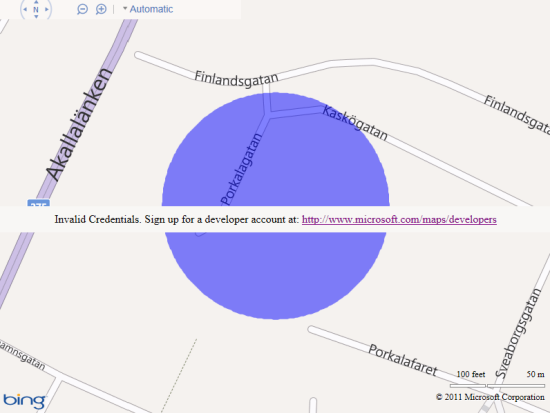
Figure 7 Geolocation Demo Mapping a Location without a Valid Key
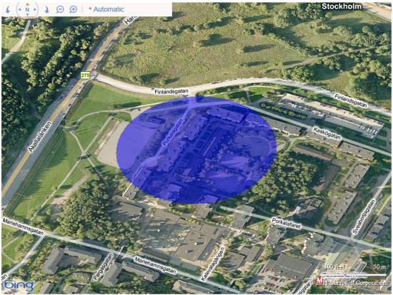
Figure 8 Geolocation Demo Mapping a Location after Insertinga Valid Key
To see other examples of geolocation, which map your location using a push pin, visit IE Test Drive or attend an HTML5 Web Camp.
Learn more about geolocation here:
§ How to Create a Location Aware Web-Site
§ W3C Geolocation API in IE9/10
§ W3C Geolocation API Spec
About the Author

Danwei Tran Luciani is a developer evangelist at Microsoft. Her current focus is HTML5 and the next version of Windows. When she isn’t putting her M.Sc. degrees in Software Engineering and Interaction Design to use, she enjoys playing on the XBOX and geocaching. She tweets regularly at @danweitran and blogs sporadically at http://blogs.technet.com/danweitran.